Custom Search

jueves, 21 de octubre de 2010

Santa Maria island

Santa Maria , Portuguese for Saint Mary, is an island located in the eastern group of the Azores archipelago (south of the island of São Miguel) and the southernmost island in the Azores. The island is primarily known in the islands for its white sand beaches, distinct chimneys, and dry warm weather that makes them unique in the Portuguese islands.


It is located in the southeast corner of the Azores archipelago, 100 km south of São Miguel, and 600 km from the island of Flores (the western most island in the archipelago). Geologically, it is the oldest island in the archipelago, with formations that are 8.12 million years old. Due to its age, and no historical evidence of volcanism, the geography of the island tends to be more mature and includes larger deposits of sediments then can be found on the other islands of the archipelago. Similarly, marine fossils have been discovered on the island (in Prainha and Lagoinhas) that date back 117-130 million years (the Pleistocene epoch), and others (in Ponta do Castelo) dating back 5 millions of years (to the end of Miocene and beginning of the Paleocene. These deposits are evidence of an older island environment associated with both volcanic and sedimentary development. Generally, Santa Maria is known for the lack of volcanism during period of human intervention, although seismic events are common due to its proximity to the Glória Fault, a offshoot of the Azores-Gibraltar Transform Fault.
The island is 97,4 km², with a ovular shape, extending from the northwest to southeast generally characterized by two geomorpholocial regions:
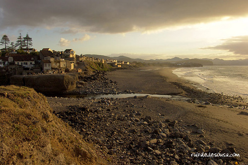
  • A dry clay plain in the west, occupying two-thirds of the island, with its highest point 277 meters above sea level (near Piquinhos). Due to the impermeability of the soils, this regions is arid with fewer leafy plants or grasses. To the north and south the principal points of colonization occurred (Anjos and Vila do Porto, respectively), and 65% of the current population resides in this region, which includes the parishes of Vila do Porto, São Pedro and Almagreira. Airport lands represent the largest use of the space, as the Santa Maria airport is located along the western coast taking advantge of the plain and lack of natural obstacles. River valleys along the north and south divide many of the communities.
  • The eastern one-third of the island is composed of eroded hills and mountains, covered by areas of thick vegetation, pasture lands and river valleys. The tallest points on the island, Pico Alto (590 m), Cavacas (491 m) and Caldeira (481 m) are located in this region, which includes the parishes of Santa Bárbara and Santo Espírito, the more rural and agricultural lands on the island. This is a region of higher levels of humidity, with greater instances of wind, fog and precipitation, resulting in rich vegetation and endemic plant species.
Volcanic in origin, the geology of the island is characterized by a substrata of basalt deformed by a series of fractures in a northwest-southeast orientation. This is interlaced with lode and deposits of mafic silicate material. In addition, there are several calcium encrusted fossil deposits associated with marine formations, during a period of formation associated with Surtseyanactivity. The presence of these depoists, unique in the Azores, gave rise to the lime (calcium oxide) industry during the 19th Century.
The fossil deposits, usually located approximately 40 m above sea level, have generated great interest in the scientific community, resulting in several paleontological studies in the 18th century, including Georg Hartung (1860), Reiss (1862), Bronn (1860), Mayer (1864), Friedlander (1929) and José Agostinho (1937). The Regional Nature Reserve of Figueiral and Prainha, which includes tha Natural Monument of Pedreira do Campo, were created by decree of the Regional Assembly in order to preserve and protect this area of natural geological interest.

Soils in the drier western region are predominantly red clay, a consequence of natural alterations associated with pyroclastic deposits during the Palaeocene period, when the island's climate was warmer, more humid and the median sea level was 100 meters below current sea levels. These conditions allowed the formation of a fine clay, used later to support the pottery industry and export market (primarily to Vila Franca do Campo and Lagoa on São Miguel to be used as matéria prima of their traditional pottery. In Barreiro da Faneca the Regional Assembly decreed a protected plain of this arid soil in order to protect and preserve its characteristics.
Generally, the island coast is ringed by steep cliffs, finding their prominence in the area of Rocha Alta (340 m). In addition, several protected bays along the coast shelter white sand beaches or are guarded by many rocky islets. these include the villages of São Lourenço (and its islet), Praia Formosa (and its long sandy beaches) or the craggy islet of Lagoínhas in the north coast. Forestry, covering about 19 hectares, is confined to high-density Cryptomeria trees planted along the slopes of Pico Alto, and unkept parcels of wild plants dominated by mock orange (Pittosporum undulatum), common juniper (Juniperus communis), and laurel (Laurus azorica).


    Due to the varying geomorphology, the population built homes dispersed throughout the island, forming small nuclei along zones with access to potable water (in the west) and in the valleys (in the east). Traditional homes were constructed from the ubiquitous black volcanic rock, painted white, with doors and windows accented in the available colors of the day. The chimneys of these homes are unique since, heavily influenced by styles from the Alentejo and Algarve, these were ornate or simple, but generally different from house to house.
    Politically, the island is one municipality, Vila do Porto, with a poulation of 5,578 inhabitants (2001), divided into five parishes:
    • Vila do Porto (parish), which includes one-third of the island, covering the western plain, the Airport and local communities such as Anjos and Santana encompassing 2,997 of the islands citizens.
    • São Pedro. The northern parish, it includes the communities of Fátima, Paul and Pilar: 841 inhabitants (2001);
    • Almagreira; the southern dry zone and transitional space that includes Praia Formosa and parts of the mountainous areas of Monteiro and Bom Despacho: 537 inhabitants (2001)
    • Santo Espírito: the eastern corner covering Maia, Glória and Fontinhas: 723 inhabitants (2001)
    • Santa Bárbara, the northern and eastern parish that includes Lagoínhas, Norte and the São Lourenço: 480 inhabitants (2001).


    The island's economy passed through much of the cyclical evolution associated with the Azores. Initially, the economy was based on the production of wheat and woad, until the 16th century, evolving slowly to a subsistence economy based on cereal crops. This was also a period of pottery production, and export of the fine red clay to artisans on São Miguel (for the production of the same).
    Generally isolated from the traffic between the New World and Europe the island depended heavily on agriculture until the 20th century, when US forces established the Airport in Ginjal. It became an international link after 1944, taking on a central position in trans-Atlantic air traffic during the mid-20th century. The island became dependent, almost absolutely, on the airport: first, during the phase of construction (when Marienses were involved in the construction or support) and later when air traffic controlin the north atlantic corridor was based in Santa Maria (FIR Oceânica de Santa Maria). For many decades, the airport at Santa Maria was the gateway to and from the Azores until the construction or renovation of smaller fields on other islands. Evolutions in the aviation industry (primarily of long-range airliners) removed the importance of Santa Maria as a trans-Atlantic stop, and other airports (such as those in Lajes, Horta and Ponta Delgada), better equipped and logistically advanced diminished the importance of activities on Santa Maria. The European Space Agency (ESA) established a satellite tracking station at the end of the 20th century, rekindling the debate on the island's dependency on the aviation sector.
    In comparison with the other islands, the raising of cattle and milk production never attained the same level of dependency. Regardless, agriculture is still the predominant activity in the municipality, occupying 47.6% of the land. This activity is usually confined to small ventures, involving forging plants, small pastures and permanent holdings. Secondary industries are dominated by civil construction, sawmills, tile and block factories, artisan/handicraft producers and fishing. There are several commercial species of fish in the waters around Santa Maria, such as SheepsheadVejasRed SnapperGrouperWrasseMackarel,AchoviesNeedlefish and Frigate tuna.
    As with the rest of the Azores, tourism makes-up an important tertiary sector, associated with nautical activities such as sailing, windsurfing, water-skiing, sport fishing (TunaSwordfish, and Grouper) and scuba-diving, beach activities, pedestrian hiking and, for some, rabbit hunting. São Lourenço, Praia Formosa, Maia and Anjos are known as summer tourist centers, attracting visitors to the beaches, natural pools, summer cottages/homes and festivals.


    Mariense culture, much like the rest of the Azores, is heavily influenced by traditional religious festivals and feasts. In particular, the festival of the "Divino Espírito Santo", closely tied to the 14th Century Queen Isabel, was implanted during the island's colonization by the Order of Christ and Franciscan monks and continues to mark the islands' calendars. These festivals include a religious ceremony, the "crowning" of one or more children with a silver-plated crown adorned with the symbols of the Holy Spirit, and culminates with a grand feast on seventh Sunday following Pentecost. On the occasion of these feasts, a traditional soup of bread soaked in a meat broth is distributed freely at the "Irmandades" and "Impérios" across the island.
    In addition to parochial celebrations associated with local saints, the island celebrates the festival of Senhor Santo Cristo dos Milagres. On August 15 of each year, the municipality also celebrates a festival in honour of Nossa Senhora da Assunção (Our Lady of the Assumption), the patron saint of Vila do Porto.
    During the last week of August, Praia Formosa is home to a world music festival: Máre de Agosto. The beach community is regularly overrun with tourists and local visitors, who travel to the island to listen to world music acts, who in the past have included: John Lee Hooker Jr.Kíla, Skatalites, Angélique KidjoRui Veloso and Gentlemen.
    Annual festivities com to a private close with the festival of the Confraria dos Escravos da Cadainha, in Anjos, at the beginning of September. A secular celebration, it is a fraternal private social and cultural event that celebrates the defense of Santa Maria (and in particular Anjos) from pirate attacks. It is a supported by the Centro Cultural Cristóvão Colombo.
    Based on the natural resources of clay and wool, the handicraft industry in Santa Maria is centered on pottery, ceramics and wool sweaters, ornate sheets, blankets, towels and other embroidery. Homespun garments include coarse woolen jerseys, embroidered linen shirts, embroidered women's jackets and estamin suits. Similarly, straw hats, baskets and various other objects traditionally made from wood, fish scales, corn flask and metal are sold as souvenirs. These activities have been organized by the Santa Maria Handicrafts Cooperative, which also promotes other unique Mariense products: bread, sweets, pastry-making and weaving.
    Traditional music and folk dancing are heavily influenced by the styles of theBeiras and Alentejo region. Several folk groups have developed on the island that reproduce the clothing styles, the music and traditional dance. Due to factors such as the climate and insular environment the style of music, songs, dance and instruments used (such as the viola de arame). Many of the dances have curious names, such as Pézinho da Garça (the Heron's dance), Moda do Moinho de Mão (the dance of the Hand Mill), Alfinete (the Pin), Balão (the Balloon), and Mouros(Moors). The Museu Etnográfico de Santo Espírito is am important place to investigate aspects of the history and culture of the island.
    Apart from the Sopas do Impéro (served during Pentecosts), Santa Maria has a rich gastronomic history that includes Sopa de Nabos (a turnip soup), Bolo de Panela (a cake), Caçoila (a thick meat stew in traditional ceramic pot), Molho de Figado (a liver stew/sauce), Sopa de Peixe (a fish soup), and Caldeirada de Peixe (a mixture of fish or seafood in broth and/or bread). Sweet desserts, such as Suspiros (meringues), Melindres (honey cakes), Biscoitos EncaneladosTigeladas (a pudding), Biscoitos de OrelhaBiscoitos BrancosBiscoitos de Aguardente and Cavacas (sugar-coated biscuits), are also popular.
    Similarly, the wines of the São Lourenço foothills, as well as other wines and sweet liqueurs, have been commercialized. These include Vinho Abafadinho and Vinho Abafado (both fortified wine liquers), Licor de Amora(mulberry liquer), Licor de Leito (milk liquer) and Aguardente, which are made using traditional techniques and favored following a dinner.

    São Miguel Island


      São Miguel Island , nicknamed "The Green Island", is the largest and most populous island in Portuguese Azores archipelago. The island covers 759 km2 (293 sq mi) and has around 140,000 inhabitants, 45,000 of these people located in the largest city in the archipelago: Ponta Delgada.

      São Miguel is bisected by many faults from the northwest to southeast in the direction of the Terceira Rift, a triple junction of the EurasianAfrican and North American tectonic plates. This system is best expressed in the western part of the island with extensive geological formations, such as the Mosteiros Graben(along the western flank of the Sete Cidades Massif), the Ribeira Grande Graben (along the northern flank of the Água de Pau Massif), and the many cones and fissural structures along the interior of the island. In the ancient crater of Furnas the faults are aligned west-northwest to east-southeast. Zbysewsky (1959), among others (note references) identifies eight geomorphological structures on São Miguel that correspond to the formative features that built the island, including:
      • The Sete Cidades Massif - an area that occupies the extreme western part of the island, and corresponds to a central volcanic crater and lake-filled caldera, with various cones, deposits of pumice, lava domes and maars. In the northeastern flank of this volcano the Mosteiros Graben, a tectonic structure created from the collapse of lands and located along a northwest to southeast orientation. Along other regional fractures and radial faults there are ancient spatter cones and lava domes;
      • The Picos Region - is situated along a northwest-southeast alignment, and defines a range of spatter cones and relatively level ground between the Sete Cidades and the Água de Pau Massifs;
      • The Água de Pau Massif - this central feature corresponds to the central volcano on the island, and includes the Lagoa do Fogo (Lake of Fire), many lava domes and pumice cones. On the northeastern flank of the Massif the Ribeira GrandeGraben is visible, representing a tectonic depression oriented northwest to southeast;
      • The Achada das Furnas Plateau - a region with a central plain marked by cones and maars, with deposits along a west-northwest to east-southeast and northwest to southeast;
      • Furnas Volcano - located in the eastern part of the island, along the southern coast, and comprising two ancient calderas, occupied by a lake (Lagoa das Furnas). Within the system one can find many pumice cones, maars and lava domes;
      • Povoação Volcano - comprising a central caldera, generally well-eroded and whose southern rim has disappeared to the southern coast. Within its interior, marked by several river-valleys and cliffs, are several spatter cones;
      • The Tronqueira Region - it occupies the extreme easterly portion of the island and corresponds to a mountainous region, divided by many river-valleys that are usually delineated by tectonic fractures;
      • The Northern Coastal Platform - located along the northeastern portion of the island, and marks a zone of relatively moderate topography, limited by the coast to the north and the northern crater rims of Furnas and Povoação volcanoes to the south.

      These geomorphological structures have resulted from millions of years of compound growth that began in the eastern portion of the island; around 4 Million years ago the Nordeste Volcano burst from the ocean floor in effusive and fissural eruptions. These eruptions were composed of basaltic lava flows and spatter cones who's products reached a height of 1,100 metres forming the mountainous region of Tronqueiro, Planalto dos Graminhais, Espigão dos Bois and Pico Verde (finding its maximum extent in Pico da Vara). But, about 950,000 years a secondary volcano system (Volcanic Complex of Povoação) supplanted the eruptions of the Nordeste Volcano, responsible for new basaltic lavas and pyroclastic deposits. With an age of 200,000 years the third volcano on São Miguel, the Água de Pau Volcano started erupting on the western flank of Povoação volcano in two phases. The first phase, composed of the older materials, erupted from lava flows and Trachyte pyroclasts, the secondary phase corresponded to volcanic products that began erupting 400,000 years ago. These latter deposits included pyroclastic, trachyte flows (lava and surges), mud flows and a mixture of basalts. In what would become the western portion of the island a fourth volcano formed: the Sete Cidades Volcano erupted 200,000 years ago and continued to erupt until about 36,000 years ago. Between 100,000 and 3,800 ago fissural eruptions of integrated lava and basaltic pyroclastic deposits occurred in the center of the island between Água de Pau and Povoaçãp, forming the Fissural Volcanic System of Congro. These eruptions were explosive and fed by activities in the neighboring volcanic systems. At about 100,000 years a secondary system developed along the frontier of the Povoação volcano, the "Furnas Volcano" complex (the youngest volcanic system) in three phases mixing pyroclastic surges, trachytes, and lava flows, as well as explosive materials. Finally, two layers of deposits formed the Fissural Volcanic System of Picos between the volcanic Água de Pau and Sete Cidades from 31,000 years ago unifying the island. This formation integrated lavas, basaltic pyroclasts, tuff cones and trachyte domes into two layers (referred to as the Ponta Delgada and Penhal da Paz sub-depoists) and compiled to about 5000 years ago.

      The ancient laurisilva forest has mostly been replaced by cultivated fields and imported trees and plants, such as the ubiquitous cryptomeria trees. There are some hot springs (caldeiras), generally located in the center of the island, in the area stretching from Povoação to Nordeste.
      The peak area between Sete Cidades and Fogo is a monogenetic volcanic field composed of 270 volcanoes. They are primarily made up of basaltic cones which were formed during Strombolian and Hawaiian-style eruptions. This is the part of the island with most recent volcanic activity. The youngest volcanoes are relatively well dated. It is estimated that 19 eruptions have occurred during the last 3,000 years. Several eruptions have been witnessed and recorded by people. The last one took place in the 17th century. The most famous eruption is known as Fogo 2, occurring in 1652.
      The highest elevation on São Miguel is the Pico da Vara at 1,103 m. Lying at the eastern end of the island, it is the focus of aSpecial Protection Area containing the largest remnant of laurisilva forest on the island, which is home to the endemic andcritically endangered bird, the Azores Bullfinch.

      • Owing to the predominance of volcanic cones and craters in the interior, human settlement has developed primarily along coastal and interior plains. In addition, there are several communities that have developed within ancient craters (such as Sete CidadesFurnas or Povoação, river-valleys (such as Ribeira ChãPilar da Bretanha) or coastal deltas (Mosteiros). Regardless, these settlements were largely agrarian and concentrated around the parish churches and the many fertile parcels of land. The communities were largely isolated throughout the year, owing to the greater distances and rough landscape of the island, and only became integrated with the development of the many road networks that circle and bisect the island. Two cities have developed, largely because the island was divided by mountainous volcanic cones in the interior: Ponta Delgada and Ribeira Grande. Administratively, the island is governed by five municipalities, with Ponta Delgada and Ribeira Grande having more administrative functions associated with their larger populations:
        • Lagoa - the youngest of the municipalities of São Miguel, with a population of 14 126 inhabitants, and incorporating the south-central parishes east of Ponta Delgada;
        • Nordeste - literally the north-eastern municipality, well known for an abundance of natural vegatation and the highest point on the island, Pico da Vara;
        • Ponta Delgada - the municipality although including the hihgly industrial city of Ponta Delgada, also includes many rural parishes, as well as the large crater of Sete Cidades;
        • Povoação - home to the first colony on the island, Povoação is located in the south-east corner and includes active and dormant volcanic features, includingFurnas and the crater of Povoação;
        • Ribeira Grande, São Miguel - second largest municipality, with 30,852 inhabitants (its city received its charter in 1981) and incorporates an extensive area of the northern coast; and
        • Vila Franca do Campo - located along the southern coast between Lagoa and Povoação, Vila Franca was the location of the historical capital of São Miguel, until it was almost destroyed by earthquake and landslides in 1522.


      São Jorge Island


      São Jorge (Portuguese pronunciation: [sɐ̃w̃ ˈʒɔɾʒ(ɨ)]) is a Portuguese island in the central Azorean archipelago of Portugal. It is separated from its nearest neighbors (Pico and Faial islands) by a 15 km strait (consequently, the three islands are sometimes referred to colloquially as the "Triangle" group or just "The Triangle"). São Jorge's is a relatively long thin island with tall cliffs, and where the population (approximately 10,500 habitants) is concentrated on various deltas along the north and south coasts (its east to west length is 53 km and its north to south width is 8 km and its area is 237.59 km²).


      Unique among the islands of Azores, São Jorge is uncharacteristically long and slender and susceptible to ocean erosion. The island was built on fissural volcanism associated with the plate tectonics of the mid-Atlantic Ridge and a transform fault that extends from the Ridge to the island of São Miguel (referred to as the São Jorge Fault). Through successive fissural eruptions the island was built-up: the only remnants of these forces are the line of volcanic cones that extend along the central ridge (approximately 700 metres in altitude).
      The island was built-up from successive morphological structures of progressively younger materials, these include:
      • Topo Volcanic Complex - predominantly built of basalt, hawaiite, and mugearite lavas and pyroclastic deposits and Strombolian cinder cones. Materials in this formation were produced are about 600,000 years in age.
      • Rosais Volcanic Complex - consisting of the northeastern portion of the island, with a similar composition to those materials in Topo.
      • Manadas Volcanic Complex - most recent formation composed of Strombolian cones and two Surtseyan cones (Morro de Lemos and Morro Velho), as well as craters and tuff rings resulting from Phreatomagmatic activity.
      The island is 55 km in length from the Ponta dos Rosais until the Topo Islet and a maximum width between Fajã das Pontas and Portinho da Calheta (approximately 7 km). The highest point is Pico da Esperança at 1,053 meters. The island has an area of 246 km², with an obvious difference in the relief between the western and eastern portions of the island: the western coast is ringed with cliffs, while the eastern coast is morphologically smoother. Similarly, the contrast between the northern and southern coasts are obvious; apart from several deltas (fajãs) on both coasts, the northern coast has sharp cliffs, while the southern coast is less inclined. The majority of the cliffs in the northeast are between 300 and 400 m with severe slopes (between 45º and 55º). In this area, many of the fajãs, some composed of lavas (Fajã do Ouvidor, Fajã das Pontas and Fajã da Ribeira da Areia) and others dendretic (Fajã de João Dias and Fajã da Penedia), are visible. In the southwest the cliffs are approximately 100m in height and most settlements are located along the lava deltas, such as the Fajã das Velas, Fajã da Queimada, Fajã Grande and Fajã da Calheta.

      Being located in the middle of the Atlantic Ocean, in an area of high pressures the island benefits from the influence of the Gulf Stream that maintains water temperatures between 17º and 23°C, and atmospheric temperatures hovering between 13° and 24°C. Annual humidity hovers around 75% and the level of precipitation has molded the physical appearance of the island.


      The geomorphology of the island (its high cliffs, rough central plateaus and scattered fajãs) resulted in the concentration of human settlements along the coast. Historically these communities were linked by coastal ports since the trails in the interior were barely transitable. Consequently, communities were isolated from one another necessitating local solutions to common problems and building local ties between families. Velas, Calheta and Topo developed partially due to well developed ports and local economies, in addition to administrative necessity and central positions. The settlements developed with immigration from Spain and Flanders, principally by settlers brought by the Ávilas and by Willem van de Hagen.
      Administratively, São Jorge is divided into two municipalities: Calheta in the east with five parishes and Velas in the west with six parishes. The rural population is basically aligned along the lines of communication divided by areas of unpopulated pastureland between localities.


      After a period of small subsistence agriculture, the local economy began to concentrate on a few chief exports: initially, lichen (Roccella tinctoria) and woad (Isatis tinctoria), later the introduction of wheat and corn crops. Woad was one of the most important exports from São Jorge and the Azores; it was initially introduced by Willem van der Hagen around 1490, and exported primarily to his countrymen in Flanders. Both woad and lichen were very popular in central Europe as a dye.
      These exports were later superseded by grapes and wine after 1571 and endured for the next three centuries. It was first disseminated along the southern coast, owing to the fertile soils, and adapted well to many of the fajãs of Calheta (including Fajã dos Vimes, Fajã de São João, Fajã do Ouvidor, and Fajã Grande), as well as the areas between Ribeira do Almeirda and the parish of Queimadas (in Velas). These were generally considered lands that were not adequate for cereal cultivation, but where vineyards flourished. The majority of the wine production was located in the area between Queimada, Urzelina and Manadas, with grapes of the Verdelho and Terrantez castes, as well as some Bastardo, Moscatel and Alicante produced in an area that became lucrative and highly prized. Unlike the other islands, where grape vines grew on the rocky hedge-rows or around protective volcanic rocks, the grapes of São Jorge were grown between many of the natural species of bush and trees. Over the centuries many barrels of wine were produced in this method, and about 10,000 barrels were regularly exported or consumed locally. São Jorge wines were so highly esteemed that the Count of Almada, then Captain General of the Azores, created the "São Jorge" brand in order to mitigate fraudulent sales. The wine was also appreciated during the World Exposition of 1867 (in Paris, France) where it rivaled Porto wine. Unfortunately, the Oidium tukeri grape/vine disease reached the island in late 1854 and destroyed the prosperous industry. Various attempts were made to restart the wine industry, such as Francisco José de Bettencourt e Ávila, the Baron Ribeiro in the area of Urzelina, and later Miguel Teixeira Soares de Sousa and Marta Pereira da Silveira, who produced wine from the Izabela caste. Meanwhile the Filoxera disease continue to destroy many of the vineyards in the municipality of Calheta during the second half of the 18th Century, and throughout the island the disease would bring many producers to bankruptcy. The remnants of the viticulture of the island banded together around Casteletes, in Urzelina, which include João Inácio de Bettencourt Noronha, producing a new caste of wines around Urzelina and Fajã de São João.

      Orange cultivation spread in the Azores around the 17th Century owing to the environmental conditions and the fertility of the lands. The export of oranges to the United Kingdom and North America was an important phase in the island's economy; about six shipments per port were annually exported, which included about 7 million (or about 994,000 kilograms) of oranges. Orange orchards were located primarily in the communities of Santo Amaro, Urzelina, Ribeira Seca and in Fajã de São Joãos.
      Another crop to form a part of the culture of the Azores is the yam. It is widely popular and cultivated in any plot of land, and was used as an important subsistence food during the islands formative years although never becoming a major export product. It was so important that it was included in the Coat-of-Arms of Calheta, since 1694.
      Long before whale-watching became important, whaling was an important industry between the end of the 19th Century and middle of the 20th Century, where a majority of the inhabitants were tied exclusively to this economy. In strategic locations along the coast small huts were built to watch-out for whales and give an alarm to the local hunters, who would sail out and harpoon the mammals. Later, when this hunt was prohibited, the islanders began to "hunt" Albacor and Bonito Tuna resulting in the creation of two processing plants in Calheta. Fishing continues to be an important part of the local economy, although whale-watching has turned into a part of local tourism.
      While cereals, vineyards and local vegetables are still grown sporadically around the island (much like the other islands of the Azores) the economy of São Jorge is currently dependent on the dairy industry.

      The principal festivals popular on the island are not dissimilar to those celebrated on the islands of the archipelago. There are the festivals of Espírito Santo that concentrate on the many impérios around the island, and are an important manifestation of the religious character of the islands. These festivals occur every Sunday during the seven weeks before Easter, and culminate on the seventh Sunday, Pentecosts, although some traditions vary from place-to-place. Generally, there are processions to the church and masses associated with this festival, but also include alms for the poor, the serving of a meat-soup-like broth (whose methods of preparation and serving vary from community to community) and gathering of the local citizens for conversation and/or dancing.
      Velas' Semana Cultural (Culture Week) is also another festivity that mixes local traditions and cultural influences from abroad. During this week expositions and presentations of local Azorean culture are mixed with local concerts, bullfights, and finally a regata between Velas and Horta, Faial during the first week of July. Meanwhile, in the village of Calheta the Festival de Julho (the July Festival) highlights four days of festivities that brings together ethnic processions, musical comedies, theatrical presentations and local sports competitions.
      The Romarias (religious pilgrimages) are a tradition of the island's Catholic communities, and strongly linked to catastrophes associated with historical earthquakes and volcanic eruptions. The Romaria de Nossa Senhora de Carmo, which occurs annually in the Fajã dos Vimes (July 16), and the Romaria de Santo Cristo in the Fajã da Caldeira de Santo Cristo, are popular processions where many faithful walk between religious sanctuaries, praying and in contemplation, usually stopping for mass at local churches.
      The local gastronomy includes many Azorean basics, but includes local plates of fish and pork with an abundance of spices, typical of the communities visited by far eastern caravels during the Age of Exploration. Clam dishes are fairly unique to São Jorge, being the only location in the archipelago where clams are discovered (usually in the Fajã da Caldeira de Santo Cristo). Generally there is an abundance of locals sweets for local tourists, including: coscorões, roquilhas de aguardente, espécies, suspiros, olvidados, bolos de véspera, cavacos, queijadas de leite, and açucareura branca. In addition, the traditional corn-bread (made from white or yellow cornmeal) is still very popular, since wheat-based breads were generally for the privileged classes of the island. The Azorean yam was also an important base of the local diet, as well as an export product. The local São Jorge cheese has been the most important part of the local economy, resulting in the establishment of an order, the Confraria do Queijo de São Jorge, to promote the consumption and sale of this popular cheese.


      Custom Search